GPS Vehicle Tracking System
EATech Corporation is the best IoT Company in Bhubaneswar Odisha, we offers a wide range of IoT Automation services and product. A vehicle tracking system (VTS) combines the use of automatic vehicle location in individual vehicles with software that collects these fleet data for a comprehensive picture of vehicle locations. Modern vehicle tracking systems commonly use GPS or GLONASS technology for locating the vehicle, but other types of automatic vehicle location technology can also be used.Vehicle information can be viewed on electronic maps via the Internet or specialized software. Urban public transit authorities are an increasingly common user of vehicle tracking systems, particularly in large cities.
Today, GPS have been using in various areas from VTS to transportation sector, monitoring wild life and etc .As a result of developments in technology, VTS’s performance increased and application areas also widen Therefore; there are many VTS present in different types and structures. The structure of the realized application is a sub-type of cellular based VTS that is a GSM based VTS
.jpg)
Today, GPS have been using in various areas from VTS to transportation sector, monitoring wild life and etc .As a result of developments in technology, VTS’s performance increased and application areas also widen Therefore; there are many VTS present in different types and structures. The structure of the realized application is a sub-type of cellular based VTS that is a GSM based VTS
EA TECH CORPORATION provides you Applications of VTS can generally be divided into two type. First, both VTS and digital mapping applications are realized in the same project. Second, the data obtained from other sources are shown directly on the existing digital map.
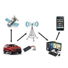
VTS is divided into three main groups according to the information substructure used: Cellular Based VTS, Radio Frequency (RF) Based VTS and Satellite Based VTS. GSM technology used in VTS is based on satellite technology. GPS signals include two types of data; position and time. In addition to these, other environmental data such as temperature, humidity, vibration can be transmitted. If the GPS receivers were in closed areas, GPS signal . not be received, thus positioning processes could not be provided, In case of interruption of GPS signal, base station data can be used for positioning. GPS data can be transmitted by SMS to the GPRS server. WEB technology, Wireless Sensor Network and PDA (Personal Digital Assistant) can be used for tracking processes. Position can be viewed on the digital map. The tracking of vehicles can be provided by oogle maps
Realized VTS was basically built on the principle of transmitting of the data from Vehicle Tracking Device (VTD) to tracking centre by SMS. A MCU was used for control processes. The data transmitted to a tracking center is processed by a VT-Software and the position of vehicle is shown on a digital map.


SMS transmission is possible in two conditions: In case of an emergency, SMS data can be sent by the help of an emergency button. Second one is to make a call over the PC in tracking center by the help of GSM modem to the GSM module on the device. If a call is received, all other operations are terminated by MCU and the number of caller GSM is recorded. An SMS is created immediately and send to that number. In the tracking center, a GSM modem is connected to a PC over a RS-232 serial communication port. GPS position data and other information in received SMS are marked and shown on the digital map by the realized VT-Software.